BLOG
Travel and photography blog by Tomas Havel.

The Himalayas - Manaslu Circuit in Nepal
The Manaslu Circuit is one of the most beautiful but the least visited in Nepal. Have a look at this blog and discover the Himalayas with me. It will take you to the rugged Nepalese mountains and diverse vegetation, along with you ascend to Larkya La Pass at 5125 m.
The Manaslu Circuit is one of the most beautiful but the least visited in Nepal. Have a look at this blog and discover the Himalayas with me. It will take you to the rugged Nepalese mountains and diverse vegetation, along with you ascend to Larkya La Pass at 5125 m.

Mt. Manaslu, 8,163 metres (26,781 ft) above sea level.
I went to Nepal at the end of March 2019. It was one of the most unforgettable and roughest journeys in my life.
I chose Trek Manaslu Circuit for several reasons. It is one of the least explored routes in Nepal, it is physically demanding and requires a special permit. Due to its close proximity to Tibet, the whole area has been closed to tourists for a very long time and today the trek is only accessible with a local guide. This distinguishes it from many other local treks. Only less than 2% of all tourists visit Manaslu Circuit every year. Most of them go to Everest Base Camp or to Annapurna Circuit. Trek goes around Mt. Manaslu (8163 m), the eighth highest mountain in the world and it is undoubtedly one of the most adventurous journeys in the Himalayas. The highest point of the trek is Larkya La Pass (5125 m), one of the most dramatic passes in Nepal.


My camera gear to Nepal

Before traveling, it is important to keep in mind that if you do not pay for the carrier (sherpa) but only the local guide, you will carry all the equipment on your own back. A 6-7-hour walk in challenging terrain awaits you daily. Most tourists carry about 12 kg, but the profession of photographer brings extra kilograms. Consider that only a tripod weighs almost 1.5 kg. I had Sony A7Rii with only one lens, an excellent Sony 16-35 f/2.8 GM. I had also new Huawei P30 Pro that offers a system of four Leica cameras with 5x optical zoom so I didn't have to carry several other lenses with me. The next 7 photos below this paragraph were shot on this phone.
I have often photographed even at temperatures -12°C and this is not, of course, good for all batteries. High in the mountains there is a problem to charge anything. It is essential to keep your phone and all batteries at your fingertips, warm, during the trek.

Birendra Lake (Birendra Tal), Manaslu Glacier in Gorkha District.
The beginning of the journey
The adventure begins with an 8-hour bus ride from Kathmandu to Sotikola. With a greater dose of imagination, the road can be called a road. In Sotikole we start out on a walking path. For the first few days, it slowly rises through a deep valley upstream of the Buri Gandaki River. The appearance of nature changes rapidly, the green vegetation ends and you suddenly find yourself in the middle of a landscape full of glaciers and massive walls of seven thousand peaks. In the village of Shyala, breathtaking snowy scenery finally opens and you see the peak of Manaslu.

The highest point - 5125 m
Really difficult part of the trek starts from the village of Samagoan (3450 m), where you can see the frozen lake Birendra. The biggest challenge comes on the day of the ascent to Larkye La Pass (5125m), the highest point on the trek. Much of the pass is covered with ice and snow all year. It is necessary to come before the wind rises and the summit suffers from fog or snow. But it is not the only thing. Sunlight also increases the risk of avalanches falling. The guide said that there was the most snow in the past 20 years.


The alarm clock rings at 3 o'clock, at half-past four, we head towards the pass. Three hours in the dark with a headlamp, in the snow and up to a steep hill. When I think my adrenaline can no longer rise, there is a roaring sound of a falling avalanche about 200 m ahead. It is an unforgettable feeling of fear, but a great sense of happiness. The white snow dust has covered the pass. Our guide again considers returning, but this time we decide to continue. The fog is denser and denser, and we approach the summit of 5125 m. On the way, I take some pictures of the sunrise, but then I concentrate on walking and keeping my hands warm.

After less than six hours we reach the summit, unfortunately, the fog is so dense that it is impossible to see one step. We are incredibly lucky, the next day the pass is snowed and closed to all hikers. A very steep descent of a snow-covered path awaits us down the pass. The rocky landscape turns into subtropical vegetation. You walk through the beautiful forests of rhododendrons, pines and junipers. As you descend, you pass terraced rice fields, wild horse meadows, and deep bamboo forests. The journey ends in the village of Dharapani, after that we have almost a 9-hour drive along the dirty road back to Kathmandu.


Back to reality
We made the Manaslu Circuit in 10 days, climbed 8000 meters and saw some of the most beautiful sceneries along the way.
After so many days we are back in civilization. You enjoy the feeling of happiness from a hot shower, and you are not able to respond to dozens of messages and e-mails after connecting to wi-fi. You find yourself back in a reality full of rush and worry.


For me personally, it was one of the longest and toughest journeys in my life. „The way is the destination“ had the right meaning here. I had the opportunity to see the peaks of snowy mountains, massive waterfalls, suspension bridges and the diversity of untouched nature. But it was not just about the natural beauty of the Himalayas. Staying in Nepal has shown me a hard-to-understand lifestyle for Europeans.
Nepal is one of the poorest countries in the world, but people still look happier there than most people in Europe. However, happiness is very relative in Nepal. I've met the friendly villagers, many amazing people and I really wish them all the best in their lives. Living in Nepal is not easy.

In mountain villages, you feel that the time stands still, the values and priorities flip upside down and the majestic mountains enchant you with their power and energy.
See you the Himalayas! It was a great honor.

THE MAJESTIC LANDSCAPE OF MADEIRA
The island comprises of stunning natural scenery, beautiful wild landscape, glittering waterfalls, dramatic coastline, and high mountains. Madeira is not the place for the beach lovers, but for the outdoors enthusiasts and especially for landscape photographers.

The island comprises of stunning natural scenery, beautiful wild landscape, glittering waterfalls, dramatic coastline, and high mountains. Madeira is not the place for the beach lovers, but for the outdoors enthusiasts and especially for landscape photographers.
Download the Complete Travel Guide
to Madeira Islands
Over 320 points of interest on Google Maps app
INTERACTIVE MAP OF MADEIRA ISLAND

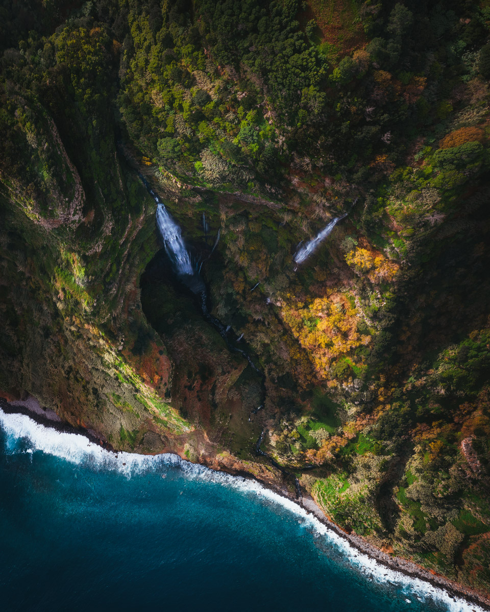
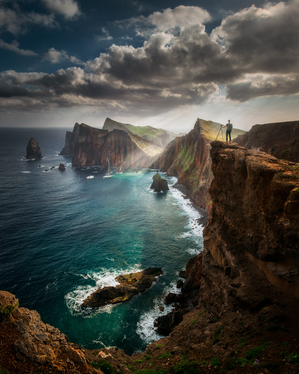
I spent in Madeira 10 days in June 2019. Let's explore some of the best places to see. The world's largest laurel forest, dramatic rock formations, colorful reefs, and many other interesting locations that are an unforgettable experience. Madeira is a popular destination and indeed there are many famous photography spots. The biggest part of Madeira is still very quiet and undiscovered so I really enjoyed it and I'm going to come back next winter. You have to do more steps to get to know the more authentic side of Madeira.

You should definitely go to the middle of the island and see sceneries like Serra de Agua, Laurisilva of Madeira, Levada dos Tornos or beautiful area of waterfalls Levada of 25 Fontes.
Let's take a look at some other great places to see:
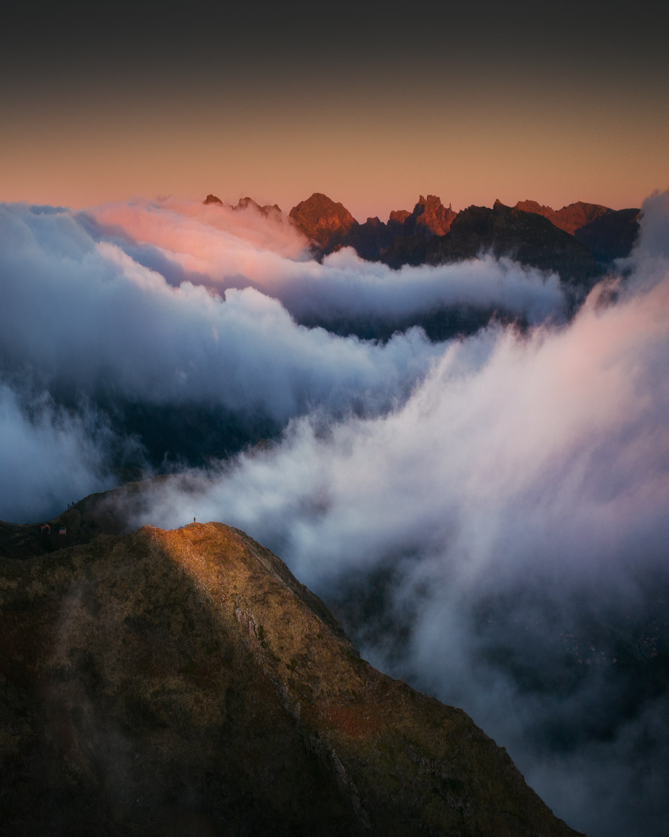
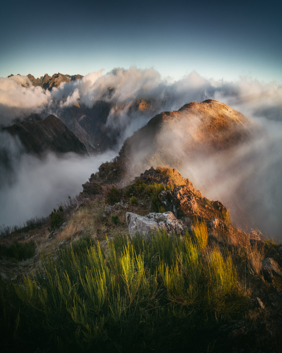
Pico do Arieiro (1818 m)
It is not possible to visit Madeira without seeing one of its peaks, this is the third highest and also one with the best view even in bad weather. It is very cold here, remember that the mountains in Madeira can be cooler even in summer. I also climbed the peak of the Pico Ruivo (1862 m), which offers a bird's eye view of Madeira.
Porto Moniz
The biggest attraction in the west of the island are natural lava pools. The pools are also very photogenic so you may know lots of images from this place. When I visited this place, all the pools were closed because of strong waves from the ocean.
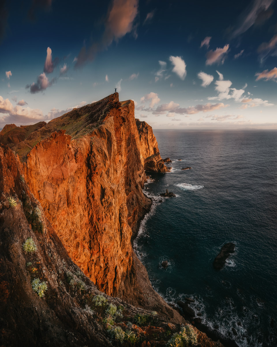
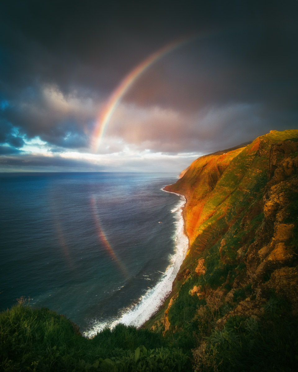
Ponta de Sao Lourenco
This location was definitely my favorite one in Madeira. While almost the whole island abounds in lush vegetation, this part is very dry. Only in the winter months there are blooming plants. That was the main reason why I visited Madeira in January. It was an unbelievable moment to see the sunrise at the easternmost spot of the island, Pico do Furado.

Madeira is a beautiful and fascinating island that makes for a stunning photographic destination. My plan is to write a more detailed article about many secret gems on this magical island, stay tuned!